- Sign In
- |
- Sign Up
- |
- My Quote (0)
- |
- CART (0)
This kit gives you the tools needed to get your airborne thermal imaging program in the air right out of the box. By combining the flight stability, gimbal technology, image transmission, and mobile app integration of the DJI Inspire 1 with FLIR's industry-leading thermal imaging technology, this package gives you the ultimate solution for dependable, rapidly-deployable aerial thermal imaging.
This kit gives you the tools needed to get your airborne thermal imaging program in the air right out of the box. By combining the flight stability, gimbal technology, image transmission, and mobile app integration of the DJI Inspire 1 with FLIR's industry-leading thermal imaging technology, this package gives you the ultimate solution for dependable, rapidly-deployable aerial thermal imaging.
Discontinued!
This product has been discontinued and is no longer available. There are no replacement options.
We can help you find what you need:
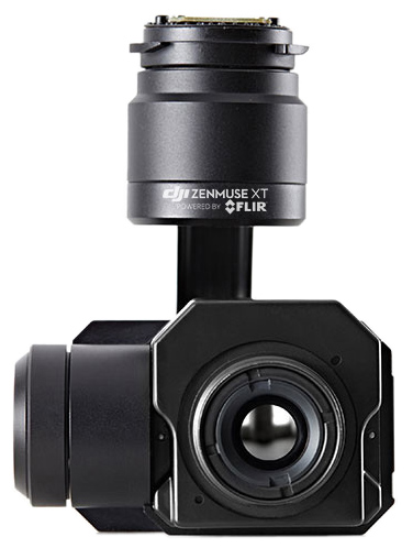
This drone package offers first responders increased support to assess the scene from an aerial perspective with the ability to see through smoke, and keep track of their personnel in large fire scenes. For search and rescue operators, it offers valuable observation capabilities in dangerous environments when time is critical. This kit includes a 336x256 resolution Zenmuse XT with a 45-degree lens. The controller receives live digital video displayed on the included Apple iPad Mini. This sensitivity provides accurate temperature measurements ideal for analytics and telemetry. Both cameras are available with four lens options to meet a variety of needs. Stabilized and controlled by a custom DJI gimbal, it provides smooth, clear imagery and 360 degrees of seamless rotational movement.
Features
Applications
DJI's Zenmuse gimbal technology has become the industry standard among demanding aerial cinematographers, and everything that makes DJI's aerial platforms world-class for cinematography also makes them the perfect platforms for aerial thermal imaging: they're stable, easy to fly, and fully-integrated with apps.
When you get right down to it, the main purpose of any drone is to position a sensor in three-dimensional space; when that sensor is a FLIR thermal imager, you expand the possibilities for drone operators and thermal inspectors alike. Using FLIR thermal imaging from small drones brings new capabilities to dozens of applications like search and rescue, the inspection of power lines, cell towers, bridges, substations, and buildings, firefighting, precision agriculture, and natural resource and wildlife protection.


| Thermal Imager | Uncooled VOx Microbolometer |
| FPA / Digital Video Display Formats | 336 × 256 |
| Analog Video Display Formats | 720 × 480 (NTSC); 720 × 576 (PAL) |
| Pixel Pitch | 17 μm |
| Sensitivity (NEdT) | <50 mK at f/1.0 |
| Full Frame Rates | 30 Hz (NTSC) 25 Hz (PAL) |
| Scene Range (High Gain) | -13° to 212°F (-25° to 100°C) |
| Scene Range (Low Gain) | -40° to 1022°F (-40° to 550°C) |
| File Storage | Micro SD Card |
| Photo/ Video Format | JPEG, TIFF/ MP4 |
| Angular Vibration Range | ±0.03° |
| Mount | Detachable |
| Controllable Range | Tilt:+35° to -90°; Pan:±320°; Roll:±15° |
| Max Controllable Speed | 120°/s |
| NTSC/PAL (field switchable) | Yes |
| Image Optimization | Yes |
| Digital Detail Enhancement | Yes |
| Polarity Control (black hot/white hot) | Yes |
| Color & Monochrome Palettes (LUTs) | Yes |
| Digital Zoom | 2x, 4x |
| Weight (Battery Included) | 2935 g |
| Hovering Accuracy (GPS mode) | Vertical: 0.5 m Horizontal: 2.5 m |
| Max Ascent / Descent Speed | 5m/s / 4 m/s |
| Max Service Ceiling Above Sea Level | 4500 m (Default altitude limit: 120 m above takeoff point) |
| Max Flight Time | Approximately 22 minutes |
| Operating Temperature Range | -10° to 40°C |
| DJI GO APP System Requirements | iOS 8.0 or later, Android 4.1.2 or later |

The Zenmuse XT can be controlled completely through the DJI GO app, providing a real-time, low latency view of what the camera sees, and instant access to core camera functions including:
Download the App


| Thermal Imager | Uncooled VOx Microbolometer |
| FPA / Digital Video Display Formats | 336 × 256 |
| Analog Video Display Formats | 720 × 480 (NTSC); 720 × 576 (PAL) |
| Pixel Pitch | 17 μm |
| Sensitivity (NEdT) | <50 mK at f/1.0 |
| Full Frame Rates | 30 Hz (NTSC) 25 Hz (PAL) |
| Scene Range (High Gain) | -13° to 212°F (-25° to 100°C) |
| Scene Range (Low Gain) | -40° to 1022°F (-40° to 550°C) |
| File Storage | Micro SD Card |
| Photo/ Video Format | JPEG, TIFF/ MP4 |
| Angular Vibration Range | ±0.03° |
| Mount | Detachable |
| Controllable Range | Tilt:+35° to -90°; Pan:±320°; Roll:±15° |
| Max Controllable Speed | 120°/s |
| NTSC/PAL (field switchable) | Yes |
| Image Optimization | Yes |
| Digital Detail Enhancement | Yes |
| Polarity Control (black hot/white hot) | Yes |
| Color & Monochrome Palettes (LUTs) | Yes |
| Digital Zoom | 2x, 4x |
| Weight (Battery Included) | 2935 g |
| Hovering Accuracy (GPS mode) | Vertical: 0.5 m Horizontal: 2.5 m |
| Max Ascent / Descent Speed | 5m/s / 4 m/s |
| Max Service Ceiling Above Sea Level | 4500 m (Default altitude limit: 120 m above takeoff point) |
| Max Flight Time | Approximately 22 minutes |
| Operating Temperature Range | -10° to 40°C |
| DJI GO APP System Requirements | iOS 8.0 or later, Android 4.1.2 or later |
The Zenmuse XT can be controlled completely through the DJI GO app, providing a real-time, low latency view of what the camera sees, and instant access to core camera functions including:
Download the App


